no no, im all for the mapping on a computer.
What I was referring to was that until recently, the Gen 3 8 zone didn’t have the ability to map on mobile devices. Only the 12z Costco & 16z had that ability.
I’m all for doing everything on a computer; please add the missing website features.
You wouldn’t use a mobile phone to do your taxes, write a program or design a building. Anything complicated is best done on a device with a big screen and a physical keyboard.
1 Like
Lol, I thought that I had missed something and Rachio had finally added the mapping on a computer. 
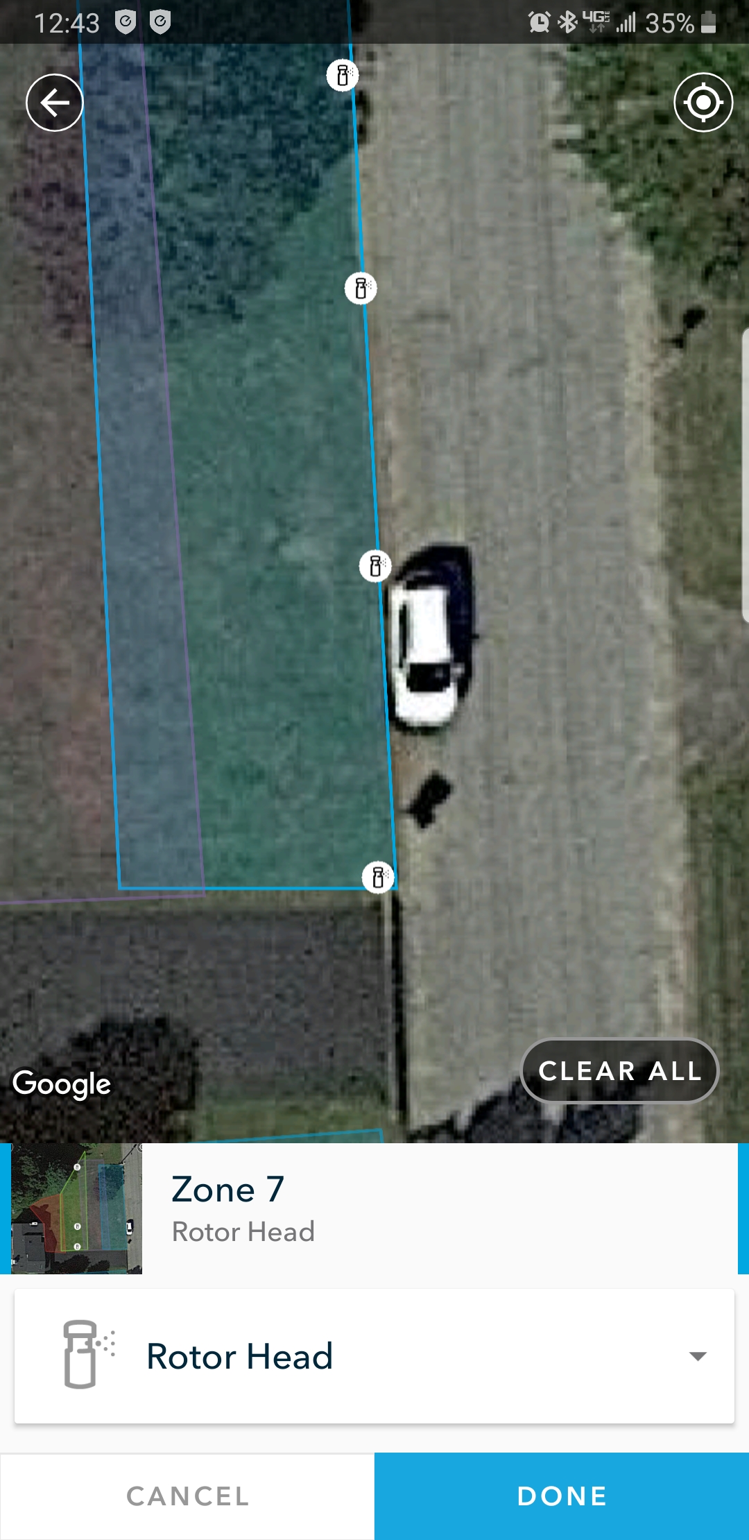
I have the costco version… After selecting to add sprinkler you can zoom in this much… Shown in pic below. I can add sprinklers 2 feet apart without issue on my cell phone. What can help you is using a stylus for a easier time when setting up.
My complaint is why not have it use GPS for sprinkler locations instead of manually guessing about where they are? I just did a rough yard map and it works great.
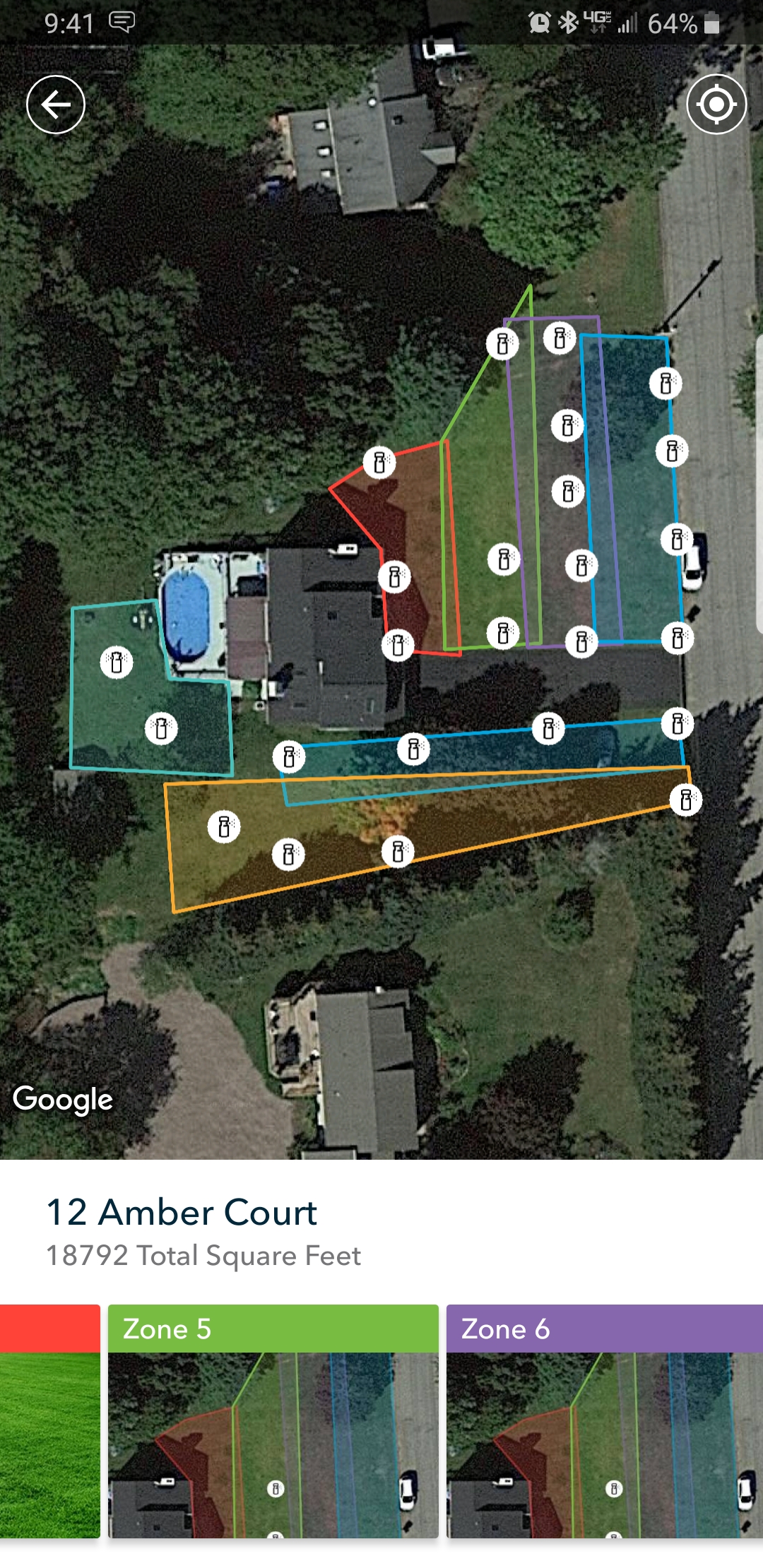
New user with the 12 zone Rachio 3. I would like to use the mapping feature but as noted by several of you it needs to work on the PC to do the mapping. It can work on my Android but why punish myself like that??
Hah , when I last looked (last year) there was no “on your computer mapping” available, so I fired up Photoshop and did it there. I did not have a nice aerial to use so eventually just made a line drawing around the google maps satellite view. Then I modified it for each zone for my thumbnails . Not elegant, but functional and it only took about an hour total.
I’ve used the DaftLogic Google Maps Area Calculator Tool which works a bit like Rachio’s, except it’s much larger and on a computer. I have my house, yard and landscaping drawn up on CAD, so can measure it very accurately. This site gave me areas within about 3% of actual, which as they say, is close enough for government work. My house appears at a slight angle, with roof lines overlapping some areas, complicating the problem, but that exists with Rachio’s too. Anyhow, I find this better and easier to use, and available to anyone.
I didn’t enter my sprinkler heads. The program doesn’t use it, so why bother?
rraisley,
Thanks for the replay. I think my desires for the map differed from yours, though I tried the daft logic and it uses the same Google map.
You see… Well, 16 months ago my wife and I decided we wanted an old house (though one that had been extensively remodeled). Enter a house from 1964. First, the inspetcor couldn’t figure out how to test the newly installed Rachio controller, we punted on that as the house had numerous new “Smart” features and all were working. When summer came around, the system doesn’t work. Giving up I called in thes prinkler pros. Valves, cutoffs, and what not were hidden, buried, or broken. $1000 later I had it working. Then a gas line rupture caused a trenching job that took out several lines, my wiring in 3 spots. Another grand. Then a new gate required drilling through a side pation. Yep, one post hole caught the wires and 2 line. $675 more. (now I have one valve that won’t turn off and looks fine, Sigh). So,my map is really to locate everything for me and whoever fixes the thing, plus the next owner. This is apparently the 3rd system that has been installed at this address. Valves are scatterd ariund the yard - covered by grass, under large shrubs and I still have two no one can find. But they are at least working.
Oh yeah, the map thing, I have 5 60+ foot oak trees in the yard so aerial views show a lot of leaves, little yard.
I feel your pain. My last house, on a half acre lot, had irrigation done that way. First house I’d owned with irrigation, so was just happy I had it. Contractor promised to give me a map, but never did. Had to rip up the yard multiple times, once to get heads off the neighbors properties, other times to either add heads or fix them.
At my current house, the system is much simpler (but not necessarily better); I took pictures during construction, and at least the valves are all in one place (as far as they could be mounted from the controller and water source, of course). 
Summary: +1 this request.
As already mentioned, I would love to use the Yard Map feature. However, it is rather difficult to do on a phone due to not being able to zoom in very far and the precision is not very good. It would be better if I could do this my computer.
However, I would suggest even further . . . It would be best if I could do this with, for example, a KML file (created in Google Earth). I created a KML file a while back that marks of each of the zones, has color coded sprinkler heads, etc., which allows probably the best precision. I know the KML can be a bit complex, but not so bad that they are hard to read. I am sure the engineers’ ability would allow for that (I am an engineer and have created and/or read KMLs quite a bit). However, something simplified would be okay, but not sure the average user would be able to create something.
I (+++++1) this as it is a feature request that needs to be inputted by Rachio is should be an easy add. I have tried many many many times and have given up on my iPhone 11 Plus and that is a large screen. Please add this to the PC web log in. This would allow me to get this accomplished in 20 minutes
Thank you RAchio in advance
1 Like
I am another +1 to get better mapping accuracy (most likely on a computer). Some Androids come with a stylus, but I don’t know of one that works with an iPhone.
I had the same issue and found a good solution: I loaded the free BlueStacks Android emulator on my PC and then installed the Rachio app on there. I can now edit my yard map using the full size of my PC’s display. I definitely recommend this!
1 Like
Does yardmap do anything for the program times and watering schedule or is it just a way to have a diagram of your zones and heads.
Diagram only
I believe it also sets the square feet for the zone in the zone’s advanced properties, which is then used to calculate gallons of water used (or saved).
2 Likes
As a work-around, I was able to setup my zones on a Samsung Dex using my mouse. Certainly up-voting original request as not all andorid devices may be capable of Dex or other equivalent desktop experience.
1 Like
I believe that a good solution is just around the corner:
+1 on this request, also on iPhone it is not possible to set draw zone points on already overlapped area… you have to be a smart cartographer to workaround this and start in the right direction…
Please add PC/Web option for this with…
+1 request, add an ability to upload your own aerial imagery (from drone from example)… mapping it on 1 year old google image is not good…
1 Like
+1 for all of these great suggestions. We need an easier way to edit the map without clearing all the existing data.