The day after, in one zone crop ET was displayed as .21 — then the next day that day’s ET went down to .16. Is a seasonal adjustment made or does it switch to PWS derived ET? Put another way, yesterday’s crop ET (.19) will likely change downward tomorrow, which is unexpected since it should no longer be a forecasted number. BTW at 100% crop efficiency for a ghost zone, my “yesterday” ET is usually within 0.01” of CIMIS calculated ETo — that’s really good.
Great question, very observant!. I believe this is due to a forecasted ET value that we use for determining if going to water “today”. We don’t use observed since we don’t have the aggregate data for the day. After the day passes we will adjust based on the actual observation for the day (we wait a couple days before actually persisting the moisture graph data). At some point I’d like to research the effects of making this less dynamic and just using the forecasted value as gospel since that is what we made our decision off of, and it should be fairly close to observed since the data just consists of max/min temps, humidity, wind, solar rad, and dew point.
We don’t use PWS data for deriving ET. Tried this in the past and we saw a big gap between forecasted ET and PWS ET. I would like to get more hyper local ET at some point.
That’s great! Our ET algorithm is built off of Penman-Monteith for the curious.
Just curious what your background is? Most people don’t get this deep into the data.
Thanks for keeping us honest. ![]()
![]()
Hi @franz, can you clarify this a bit? I understand not using PWS data for forecasted ET, because most PWS don’t forecast, but if you’re not feeding observed PWS values into the Penman-Monteith calc (along with crop coefficient, etc), then what data are you using to calculate observed/historical ET?
Hope I’m misreading your statement because I thought the point of having a PWS was to get the most accurate inputs (temp, dewpoint, UV, rads, wind, etc) for the ET calc.
We only use nationally observed data to derive ET. We used to use forecasted data for ET and allowed PWS observed data for ET but the forecasted waterings were always widely different then observed waterings since we would use the “observed” ET from the PWS to decide if we were watering or not for that day. The biggest discrepancy was wind observed from PWS stations which was usually much lower than wind from properly setup national stations. This would have us watering about half as much as was recommended since the recorded ET from PWS stations was usually much less. There is a thread about this exact topic somewhere in the community history ![]() Went back and forth with this and the approach we’ve adopted seems to be the most predictable.
Went back and forth with this and the approach we’ve adopted seems to be the most predictable.
![]()
hmm… Not sure what the point of having a PWS would be then. The closest national station to me is an airport 11 miles away that has large deviations on wind,rain, and cloud cover (which affects UV/solar) from what I observe at my house. That’s why I setup my own.
I’ll have to search for the previous thread.
Yesterday’s ET is quite accurate but once the day is two days old it seems to change. Today’s or tomorrow’s forecasted ET can be quite off — once it showed .3” but ended up being .2” — perhaps a function of my location having very poor NOAA WX coverage thus resulting in poorer digital gridded forecasts. Nearest stations are Red Bluff and Chico and both have very different climactic conditions, though Red Bluff is best for the Willows/Orland, CA area. I’d actually prefer to select a station south of Willows (Williams or Fish & Wildlife Service WX station just north of there) but it seems out of the selection radius for Weather Intelligence.
Yes — my observations agree that wind is the Achilles heal for PWS. My station has extremely erratic wind readings and they can be up to 10mph lower than actual. My temperature also reads up to 5º higher than actual. So this is a smart way to go in most cases.
I’m a geologist and GIS analyst by training and am a home orchardist. Last year I learned about ET and MAD then started getting bogged down in complicated spreadsheets. Then I realized Rachio’s IRO could do the bulk of the work for me. So now I’m trying my best to understand how Iro makes its decisions and with what data. Your response is very informative and thank you very much for taking the time to do so!!
It’s the conundrum we are in if we want to project forecasted waterings and be fairly accurate as to when the system actually does water.
![]()
I’m going to do my own tracking/analysis and just triple check we are recording observed ET correctly.
That’s awesome, and we are always open to feedback in helping the system get better. I’ve always said that the information to do this is available, but no one (well except folks like you ![]() ) would sit down and acutally record everything in a spreadsheet.
) would sit down and acutally record everything in a spreadsheet.
![]()
2 Likes
Key for the PWS is daily rain totals and if it’s freezing. Still a very important part of the equation and definitely required for my rural location.
1 Like
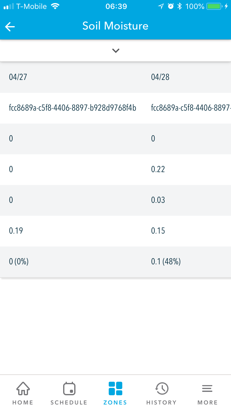
Here’s a zone I have where the ET changes fairly dramatically after two days - moving away from expected (0.19) with 100% crop efficiency. I’ve already put in a ticket for the station ID hexadecimal issue
Screen cap on 4/28:
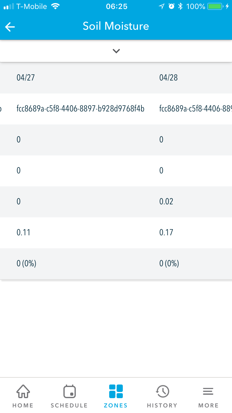
Screen cap on 4/29:
Thanks for sharing, that feels too dynamic. I’ll have the team do some research and get to the bottom of this and also get the station name fixed. It’s actually a UUID 

1 Like
Found the station ID issue, we will release a fix for that tomorrow. I’ll let you know what is discovered regarding ET.
You’re all amazing at Rachio. I do not expect support & general responses on a weekend! Thank you!
1 Like
I believe I found the issue with ET values dropping after a couple days. It was a subtle issue with how we finalize these records at midnight. Without going into too much detail we were looking for the closest national station at midnight, could not find one (sometimes), and were then using the PWS for ET . This will be patched and fixed today. Really appreciate you bringing this to our attention.
2 Likes
Hooray! Well, that’s proof that I don’t want my PWS or any other PWS being used for ET  I did notice one very late night that KRBL vanished for a period of time on the weather intelligence selection map and I got really confused but then it showed back up by morning. Glad I could be of help in finding that bug!
Yeah, this also makes me want to use the forecasted daily ET as the source of truth for that day since I’m pretty sure the forecasted data using your controller’s coordinates is going to be a little more accurate than using observed data from the closest national station one or two days behind.
I support using forecasted ET values as the nearest NWS stations are in excess of 15 miles away and in very different geographies and have just different enough climatology. The best station I can use is KRBL at 28 miles north; KCIC is in a very sheltered eastern valley location, whereas I’m in wind blown western side of the Northern Sacramento Valley — KRBL gets most of those winds with similar temperatures but they get far more convective storms, and experience more temperature extremes.
I’m going to work with the engineering team on using forecasted ET (which is what we actually use to determine today’s watering) as the source of truth for the past.
1 Like
It has been a couple of days and final ET values are as expected. Thank you and thanks to your team.
1 Like
I have been following this thread and found it interesting.
@Kubisuro when you say that ET values are “as expected” how I can know that my values are OK?
This is my data;
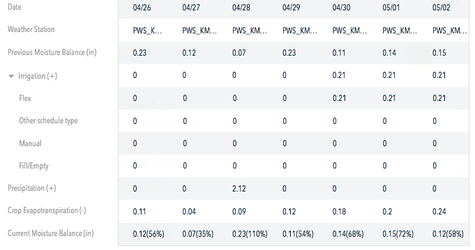
I’m trying to optimize my system for water saving / green lawn ![]()