But there isn’t any option really available in the Rachio settings that fit that. Is there an acceptable options that is “close enough” or do I need Rachio to add this as an option?
I have similar soil that goes 80 feet down. My kids call it mouse powder. The presets in the app aren’t going to be right. Assuming you are in the USA, go to the USDA’s Web Soil Survey (WSS). Hit the big green WSS button. Zoom to your location then select your “Area of Interest” its in the toolbar far right. I suggest you select at least a ten acre patch so you can see if there are different soils in your area.
When the AOI is set, it will be cross-hatched in the map view. Now hit the second tab in from left, labelled Soil Map.
There should be a Key on the left with a list of soil type in your area. Find your type and click it.
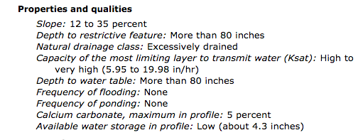
That will pop up a description of your soil. In the description scroll down until you find the Properties and qualities heading. You want to find the Available water storage line. In my case it was the bottom of that section.
You take that inches number and divide it by 12 to get the Available Water(in) number for your zone setting (ie 4.3 / 12 => about 0.37). That number is actually a PERCENTAGE and Rachio should fix that label.
The preset for sand showed 0.05 which seems insane. The preset popups do nothing in my zones since the first save. I have to enter the numbers.
The next thing you’re going to want to figure out is your Crop Coefficient which most soil publications call (Kc). Your state university agriculture department may have publications with those numbers. In my case I first had to find the mixture of grass seeds used locally via the ag dept publications. Then I searched for Kc numbers for Kentucky bluegrass and red fescue. These numbers vary by the month so you may want to average the months of your hot/dry season. In the end, I got a final average of 94%. That number is plugged into the zone as Crop Coefficient of 0.94. If you need help with that match I setup a spreadsheet I could share.
I hope this helps you. It took me about 6 hours to surf my way to this info. I’m testing it in 2 of my 8 zones right now.
Thanks for that extra info @azdavidr . Now if someone could explain why Available Water is specified is so many ways… I found a Rainbird document on Management Allowable Depletion (MAD) that used Available Water (AW) in Inch/inch units and showed sand as 0.06. My head is going to explode with the AW number being .37 and .06 for the same soil type.
@a9k If you take that original 4.3 number and divide by 60 instead of 12 you get 0.07, so the numbers match. It also makes sense to me based on a mostly sand soil. Mine is Sandy Loam and it’s at 0.12. It means that your soil retains less water, which makes sense if it’s more sandy. Indeed, the watering times will be very low since the water gets to the desired depth very quickly. You’ll also find that you’ll water much more frequently since the sand doesn’t hold on very long to the water that it is given.
To answer your question more directly, I believe that the 0.37 was derived incorrectly. It should have been 4.3 inches of water for 60 inches of soil, so to get he inch/inch number you divide 4.3 by 60. That gives you 0.07, which is very close to the 0.06 number.
100 percent silt is very unusual. I would go with Sandy loam. Knowing all of the central control system and smart controllers I don’t know of any that has a setting for just silt. Where was your soil test done? I’d feel better if cooperative extension service were doing the test. Besides giving you the soil description they will also give pH and recommendations on lime application if the pH is too acidic. I work with a person who has her masters in soil science and will see what she says about a 100 percent silt soil. I am skeptical.
So long story short, we had a geological survey done (three borings) done our property (10,000 sqft) a few years ago and basically for the first 10-13’ we have “clean silt” (US CS ML) and then “silty sand” (US CS SM). One of the borings showed free ground water at ~12’. This is very atypical for our area, but seems to be related to the creek which used to run about a block away. Theory is that it used to flood and when it did so, deposited silt on our lot (the report specifically calls out some overbank deposits in the silt).
Anyways, I looked up our AOI info on the WSS site and none of the soil descriptions of the samples match what our report says (all are some kind of loam soil). That said, the Available Water Storage based on the WSS report in our area seems to be around 8-9.5". Not sure if that number is also effectively wrong?