What Soil Type in Rachio is CeB2—Cecil sandy clay loam?

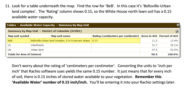
The Web Soil Survey test results show that I have CeB2—Cecil sandy clay loam. What soil type in Rachio should I specify?

CeB2—Cecil sandy clay loam, 2 to 6 percent slopes, moderately eroded

Map Unit Setting

National map unit symbol: 2th00
Elevation: 450 to 1,450 feet
Mean annual precipitation: 40 to 69 inches
Mean annual air temperature: 50 to 66 degrees F
Frost-free period: 180 to 280 days
Farmland classification: All areas are prime farmland
Map Unit Composition

Cecil, moderately eroded, and similar soils: 92 percent
Minor components: 8 percent
Estimates are based on observations, descriptions, and transects of the mapunit.
Description of Cecil, Moderately Eroded

Setting

Landform: Interfluves
Landform position (two-dimensional): Backslope, shoulder, summit
Landform position (three-dimensional): Interfluve, side slope
Down-slope shape: Convex
Across-slope shape: Linear
Parent material: Residuum weathered from granite and/or residuum weathered from gneiss
Typical profile

A - 0 to 3 inches: sandy clay loam
Bt - 3 to 48 inches: clay
BCt - 48 to 80 inches: sandy clay loam
Properties and qualities

Slope: 2 to 6 percent
Depth to restrictive feature: More than 80 inches
Natural drainage class: Well drained
Capacity of the most limiting layer to transmit water (Ksat): Moderately high to high (0.57 to 1.98 in/hr)
Depth to water table: More than 80 inches
Frequency of flooding: None
Frequency of ponding: None
Available water storage in profile: High (about 9.3 inches)
Interpretive groups

Land capability classification (irrigated): None specified
Land capability classification (nonirrigated): 3e
Hydrologic Soil Group: B
Hydric soil rating: No
Minor Components

Cataula, moderately eroded

Percent of map unit: 5 percent
Landform: Interfluves
Landform position (two-dimensional): Backslope, shoulder
Landform position (three-dimensional): Interfluve, side slope
Down-slope shape: Convex
Across-slope shape: Linear
Hydric soil rating: No
Bethlehem, moderately eroded

Percent of map unit: 3 percent
Landform: Interfluves
Landform position (two-dimensional): Shoulder, backslope
Landform position (three-dimensional): Side slope, interfluve
Down-slope shape: Convex
Across-slope shape: Linear
Hydric soil rating: No

I may be missing it in your data that you posted, but what number do you get in step 11 from these steps Web Soil Survey Instructions for Rachio Iro

3 Likes

@azdavidr posted some excellent info in Using Web Soil Survey to define your soil settings, so I’d suggest taking a look at that. It explains how to use the web soil survey to get available water as a ratio, which is the important number to enter into the Advanced settings. Sandy clay loam is somewhere between sandy loam and clay loam, so you could pick whichever is closer (see the soil texture triangle at http://support.rachio.com/article/262-choosing-soil).

3 Likes

Oops - @Modawg2k beat me to the punch! Sorry for the semi-redundant post.

.14

Cool so just really pick anything, maybe “Silt Clay”, and then adjust your “Available Water” number to 0.14 and you are good. Then just observe and make adjustments as you see fit

1 Like

I took a look again at the soil triangle and decided to use Silty Clay in Rachio since Sandy Clay is not an available option.

I also noticed that when I changed the soil type from Clay to Silty Clay, the available water changed from .14 to .16, so I manually changed it back to .14 per my soil survey results.

Thank you for your feedback, ldslaron and modawg2k.

1 Like

I wish Rachio had all 12 soil types (shown in the Soil Texture Triangle) available in the soil type drop down box.

1 Like

Yeah, last year I did a mason jar test and attempted to determine soil and AW based off measurements and the triangle and I couldn’t make heads or tail. Fortunately @azdavidr developed that great guide. FYI, no matter what soil type you put into your setting (Clay, Silty Clay, etc), that is negated when you manually adjust your AW. So really it doesn’t matter which soil you selected because you are telling the rachio your actual AW. Good luck!

I think one thing that may matter a bit besides available water is the soil infiltration rate that drives Smart Cycle. In other words, YMMV on the soak time if you pick a different soil type even if available water is the same.

@ldslaron interesting so you think that plays a part in their algorithm? I always just assumed the selecting your soil was the user friendly way to get the AW number, since you can’t adjust AW unless in advanced settings in my ios app.

Right. Take a look at http://support.rachio.com/article/283-smart-cycle-overview for more details.