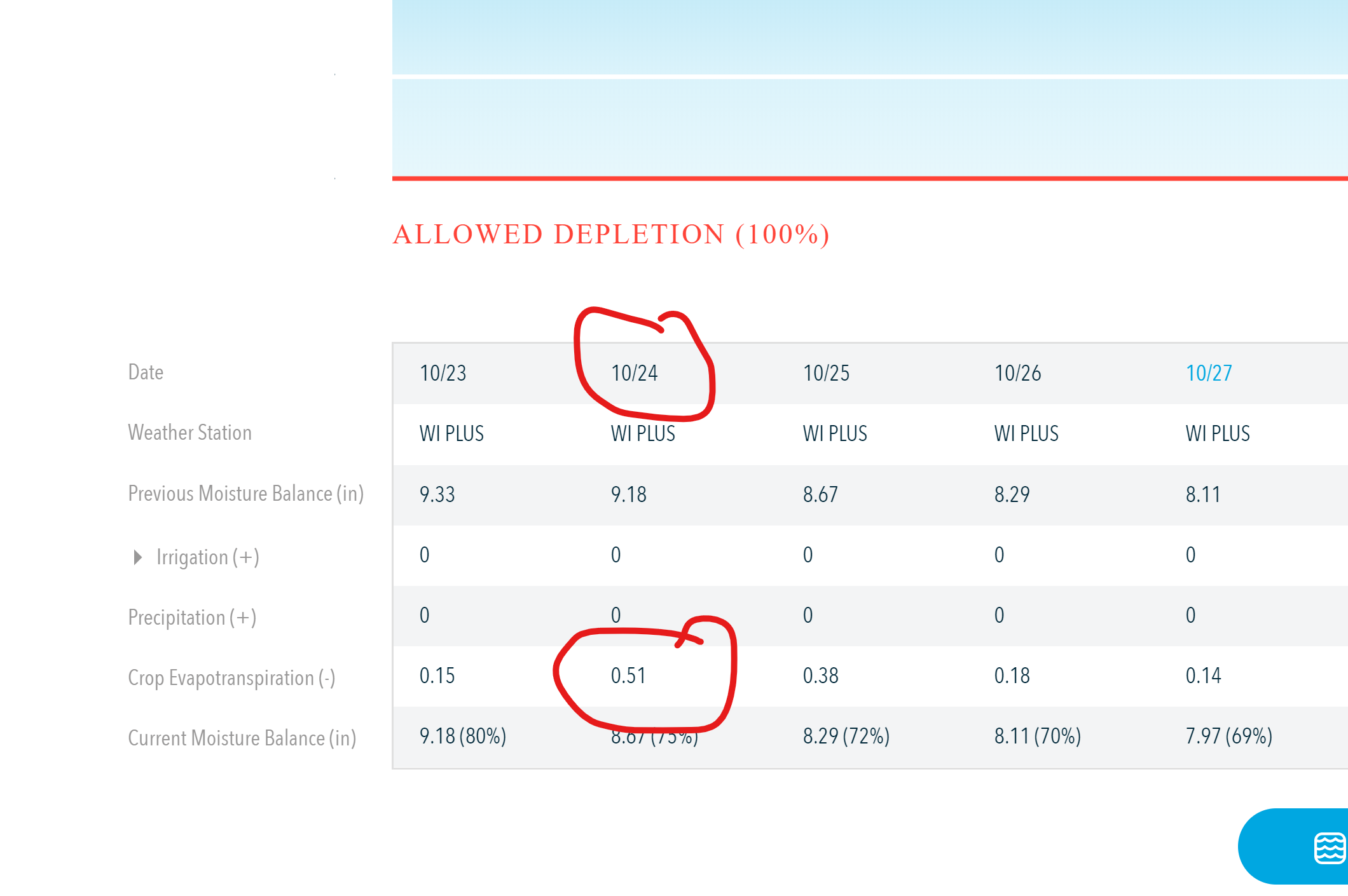
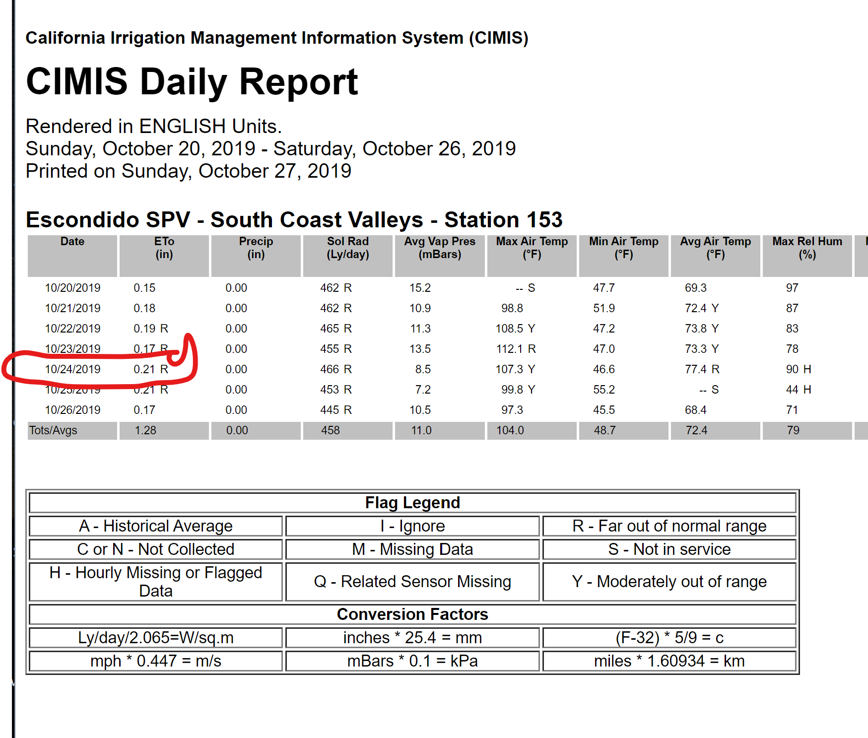
Typically my rachio gen 3 controller has ET0 readings almost the same (Weather Intelligence plus) as what is reported by the California CIMIS Station #153 which is 10 miles away and in the same microclimate. I know this because I have an unconnected dummy Rachio zone with crop factor set to 1.0 and I tend to check it on and off comparing it to the official one. Last week, we had a weather event with heavy dry winds (‘Santa Anas’) and the rachio ET0 was about 0.51inches while the CIMIS one reported 0.21inches. for the day. Any explanation for this discrepancy? Other than a couple of days like this, my ET0 matches almost exactly with the CIMIS one. I can understand that there could have been locally high gusts of winds compared to the CIMIS one. But I’ve never seen this high a ET0 number.
I am having the same issue in Ventura County. I work for a sod farm and i’ve noticed that when there is a wind event, the ETO’s are way off. Does anyone know if Rachio is looking into this issue?
Agreed…
One question why do you have AD at 100 percent?
On 10/25 it does show half inch less moisture and accounts for the CIMIS reporting ETO …it looks close.
Are you on WI only and not a WS in the area? I wonder if the UV reporting and wind delay had something to do with it, as occured in our areas gusts upwards 60 plus and hot and dry Santa Anas.
My sites , were dry as the Mojave and with the wind delay my fall color plantings are stressed.
I wonder if the CIMIS was correct as it was the same as well and then again matched Rachio on 10/26
Very late response…
I set the AD for this station at 100 percent since this was a dummy one which was not connected to any sprinkler (which the controller doesn’t know) and I didn’t want frequent nuisance notifications from the controller about turning on this particular station.
I’m not on a Weather Station local to the area but use just the Weather Intelligence Plus. The primary reason for this is that accurate ET0 numbers need properly situated and calibrated weather stations at adequate height without obstructions (based on my understanding). A sampling of the weather stations around my house showed that there was a range of temperatures in just a 1-1.5 mile radius and several of them had random wind readings (which probably meant that there were obstructions around those stations). I also didn’t want the headache of depending on one station and then having to make sure that the station was always up. My assumption is that the Weather Intelligence plus does some sort of ‘smart’ statistical analysis of the weather data in the area to come up with close to mean values. And the fact that on most ‘normal’ days my rachio ET0 was almost spot on with the official weather one (which is probably about 10 miles away) gave me confidence in WI.
I have sampled the CIMIS database’s historical data to see if these sort of extreme values for ET0 like 0.51 has occurred in the last few years and I could not locate them at least in my samples. The most likely explanation that I could come up with for this discrepancy is that the WI plus together with the local weather station data (that WI Plus uses) fails during about. I was hoping that someone at Rachio would have an opinion on what is happening.